Trail Walking La Ciotat - RB-la_ciotat-cassis - Photo
© OpenStreetMap contributors
Length
Length
12.7 km
Max alt
Max alt
380 m
Uphill gradient
Uphill gradient
647 m
Km-Effort
Km-Effort  
21 km
Min alt
Min alt
6 m
Downhill gradient
Downhill gradient
664 m
Boucle
Boucle
No
Creation date :
2014-12-10 00:00:00.0
Updated on :
2014-12-10 00:00:00.0

(0 Reviews)

Walking
Walking
4h59
Difficulty : Medium

Scan this QR Code to open this trail in the SityTrail application

FREE GPS app for hiking

Logo SityTrail SityTrail

IGN / Geographical institutes

Download SityTrail from the App Store Download SityTrail from Google Play

Logo SityTrail SityTrail Plus

The world is yours!

Download SityTrail from the App Store Download SityTrail from Google Play Download SityTrail on Huawei AppGallery

About

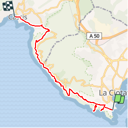
Trail Walking of 12.7 km to be discovered at Provence-Alpes-Côte d'Azur, Bouches-du-Rhône, La Ciotat. This trail is proposed by raymondfn.

Description

La Ciotat (rue Mugel), anse de Figuerolles (A-R), chapelle Notre-Dame de la Garde (A-R vue sur la Ciotat), carrière de la Vigie, sémaphore du Bec de l'Aigle, sentier au sommet des falaises (vue permanente) Cap Canaille, Baume Noir des Espagnols, pas de la Colle, vue sur les vignobles (le Revestel), Cassis (port).

Elevation profile

Positioning

Country:
France
Region :
Provence-Alpes-Côte d'Azur
Department/Province :
Bouches-du-Rhône
Municipality :
La Ciotat
Location:
Unknown
Start:(UTM)
711766 ; 4782668 (31T) N.


Close
My subscriptions